


 Bishop Hill
 Sea level and the diving horses
Climate: WG2 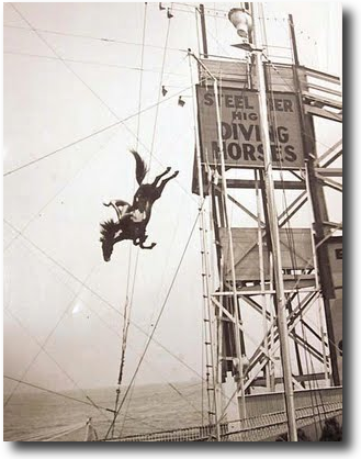 There's a fascinating article in the Washington Times (H/T Josh) by Willie Soon and Nils-Axel Morner. They tell the story of one Cyril Galvin, who found a problem with his local tide guage figures.
In examining sea-level changes for 100 years or more from stations on the Eastern Seaboard, Mr. Galvin could not find any acceleration in sea-level rise. University of Florida professor Robert Dean and Army Corps of Engineers analyst James Houston have independently reached this same conclusion.
While examining tide gauge records from Atlantic City's Steel Pier, Mr. Galvin discovered a remarkable effect apparently caused by spectators who came to watch horse-diving between 1929 and 1978. From old photographs, it was estimated that there must have been about 4,000 spectators who would come to watch. Given that this crowd probably weighed about 150 tons, the pier was subject to significant loading and unloading cycles. The initial 1912-1928 data showed the sea level rising at a rate of 0.12 inches per year. The rate tripled around 1929 when the horses began diving. When the shows were suspended from 1945 to 1953, sea level fell at a rate of 0.06 inches per year. When the diving resumed, the sea level rose again at a rate of 0.16 inches per year.
Reader Comments (60)
Actually measuring "non catastrophic sea level rise" can be a career changing activity
Appalling
@jferguson
Re Jamestown
Yes, the next time I'm in that area I would like to see the plaque. Whereabouts on the north end?
@DGH
I last saw this plaque five years ago, but my memory is that it was affixed to a building in the public area at the foot of Naragansett Street. It was discovered by chance and on foot, so i suppose it wouldn't be difficult to locate.
Sleepalot...The difference between isostatic rebound and elastic response (such as the solid earth tide - which includes ocean loading as you mentioned - or response to atmospheric events) regards the depth of the response. The elastic response is in the upper crust and can occur over hours. Isostatic response is much deeper in the earth and not elastic.
Roman Ports in the low tide-range Mediterranean, many cut out of bed rock, show a rise of 1-metre sea level since the first century AD. This averages 50-mm per century. I can find no evidence of Roman horse diving taking place in the Mediterranean.
Sea level is in the eye of the beholder. Rising for a Londoner and falling for Scrabster harbour.
Tide predictions are predictions. It is not unusual to find the actual high water time and height to be quite different from the predicted.
I don't understand why people repeat that tide gauges, because they are attached to the land, do not measure "real" sea level change.
Quite the opposite - they reveal relative sea level in every place the are located with a perfect automatic built-in adjustment for land subsidence and rise for whatever reason.
The only thing we really need to know is what is happening at the coastline and tide gauges tell us this in a simple straightforward way. There is no need for any additional "adjustment". NOAA produced a very useful interactive chart of tide gauge change over the period of record with confidence levels and what can be expected if the historical rate of change continues at that location over one hundred years.
What's not to like? It's certainly not alarming!
http://tidesandcurrents.noaa.gov/sltrends/sltrends.shtml
Jferguson
Narragansett has docks at both ends. To the east is downtown. To the west is a small marina with a mooring field. Any idea which side?
Anyway, it's a small place and the plaque should be easy to find.
DGH, East end facing Newport, sorry to be unclear.
Ignore me, who is but an ex-clown, but remember:
Sea level isn't.
The Mediterranean is inches below the Atlantic: the center of the Sargasso Sea can be as much as a meter above the coastal Atlantic waters. That's why engineers use AMSL - above mean sea level.
There are areas of the Mediterranean coast (e.g., southern Turkey) where tectonic processes have caused cities to submerge. Ancient Roman markers of sea level must be interpreted carefully.